
by ROHANI MOHD IBRAHIM
THE window seat onboard a flight from Labuan Bajo to Ende at Flores Island, in the East Nusa Tenggara province of Indonesia, offers a captivating view as you peer out at the sprawling landscape below.
It was a sight to behold. The lush hilly green landscapes dotted with villages and the black sand beaches overlooking the pristine turquoise seas, among others, make the Indonesian island an ideal secluded getaway.
As the plane descended towards the Haji Hasan Aroeboesman Airport runway, passengers were treated to a beautiful view of rugged mountains, lush green valleys and crystal-clear waters.
While Bali is Indonesia’s renowned holiday destination, Flores, meaning “flower” in Portuguese, is fast becoming a refuge for those seeking to get away from Bali’s crowded beaches and Lombok’s increasing crowds.
On arrival at the airport, this writer together with nine other Malaysian tourists on a tour of Flores was taken to a homestay at Desa Moni, the foothills of Mount Kelimutu, an active volcano. The last eruption was in 1968. It is learnt that there are 24 volcanos in Flores, with almost half still active.
The tour package from Aug 17 to Aug 25 was organised by a private travel operator, The Fadaelo Project. The scenic craters with their lakes are popular tourist destinations.
Although the distance between Desa Moni and the airport was only 60km, the coaster bus ride took more than two hours due to the rugged and challenging terrains.
Visitors at the peak of the Mount Kelimutu volcano observing the beauty of the mountain views at the Kelimutu National Park
Trio of Multi-coloured Crater Lakes
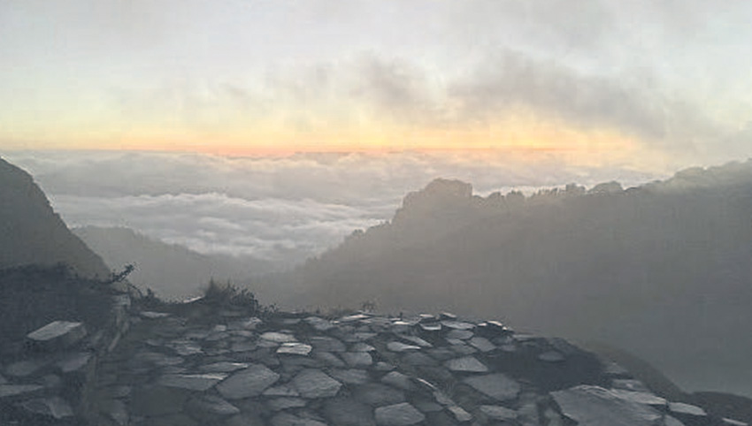
But for this writer, the real challenge was the tight schedule for the visit, waking up as early as 3am the next day. Once ready, the group began their hiking expedition to Mount Kelimutu, a dormant volcano situated in Central Flores.
Its summit lies at 1,639m above sea level. The peak consists of three volcanic mouths that were formed after an eruption in 1886 and have since then been a mystery and a place of worship for the locals.
We were off to see the sunrise at Mount Kelimutu, said to be one of the coolest sights on the island of Flores. On arrival at the entrance of the Kelimutu National Park at 4:30am, many foreign tourists were seen having their breakfast at a coffee stall there. Around 5am, we began to traverse the trail to the peak of the mountain in the dark, amid the chilly cold weather, rattling the writer to the bones.
The hike up to the summit to witness the mesmerising volcanic lakes involved a climb up a set of concrete stairs. Along the way, we were rewarded with stunning vistas of lush forests and cascading waterfalls. At the sight of the sun rising, we decided to move faster so that we could complete our 40-minute trail to our final destination.
Our target was to reach the summit of Mount Kelimutu — our final destination — with special seats prepared for us to catch a glimpse of the sunrise.
Mount Kelimutu is famous for
its tri-coloured crater lakes, each containing its own distinct colours of red, blue and green water. The three volcanic lakes are known to regularly change colours. Experts believe that it depends on the activity of the volcano. Unfortunately, what we saw at that time was only green-coloured lakes as the mountain was engulfed in a thick blanket of mist.
According to the Lio ethnic community residing in the surrounding areas of Kelimutu National Park, the lakes at Kelimutu are believed to be the dwelling place for the spirits. The blue lake is the resting place for the elderly souls, the green lake is where the young souls reside, while the red lake is where the bewitched souls rest, those who did evil during their lifetime.
The Lio people believe in the animistic belief system where they still worship ancestors and nature. It is for this reason the Kelimutu National Park is dubbed “The Land of Mystical Beauty”.


The beauty of Penggajawa Beach — clear blue sea waters and bluish-green stones on black sandy beaches
Graveyard at House Compound
After almost an hour at the Kelimutu summit, we headed back to our homestay before proceeding with our 180km journey to Bajawa. The five-hour coaster bus journey offered panoramic views of the lush green mountains interspersed with pristine beaches.
We stopped by for lunch at Penggajawa Beach or also known as Batu Hijau (Green Stone) Beach, which has its own charming scenery. It is blessed with clear blue sea waters, beautiful natural surroundings and the spread of bluish-green stones on its black sandy beaches.
While no Rest & Relax (R&R) facilities are available similar to Malaysian highways, visitors need only to drop by at any local resident’s house.
Like most rural folks in Indonesia, the villagers here are known for their hospitality. You can just stop over at their house if you need to use the toilet.
Once you visited them at their house, they welcomed us with warmth and smiles, and in return for their hospitality, we presented them with some souvenirs.
During our visit, a common feature at most houses we visited was the presence of a graveyard at almost every house compound. It is learnt that the graveyard is the burial ground of the land owner, aimed at ensuring the land is not sold by their future generation.
One of the most enriching aspects of visiting Flores Island is immersing in its vibrant and diverse culture. Flores is home to various ethnic groups, each with their own unique traditions, languages, and craftsmanship.
Kampung Adat Tololela
On arrival in Bajawa at about 4pm, we then proceeded with our next trip to watch the sunset at Mount Inerie, Ngada, which means “beautiful mother” and is regarded as a mother for the local community.
Sitting at 2,245m above sea level, Mount Inerie dominates the Bajawa skyline. It is the highest volcano on Flores Island and is one of the most popular peaks in Indonesia. The shape of Mount Inerie resembles a pyramid with a pointed tip, where, viewed from its summit, the mountain casts a perfect triangular shadow over the valley. The volcano is still active and it last erupted in 1970.
Regarded as the island’s icon, its beauty is best viewed from the top of Bukit Watunariwowo or Bukit Avatar. Surrounded by the lush green forest, the panoramic sunset with Mount Inerie in the background was simply incredible and breathtaking.
The next day, we were taken on a tour at the foothills of Mount Inerie and stopped over at Kampung Adat Tololela, which has a height of 650m above sea level.
Given that the area has been classified as disaster-prone, visitors were only allowed to go the village by taking a motorbike or a small lorry.
Among the first that caught our attention on arriving at the village was its cleanliness, with the traditional house made of bamboo and thatch. At the settlement which is home to some 98 people, the rumah adat is unique in that no nails are used to build them which is resilient, especially during an earthquake.
As the name Inerie suggests, the community in this area practises the matriarchal system that revolves around the principle of mother-rule in which mothers or women are at the top of the hierarchy.
According to a resident Uni Leko, 29, although the Tololela villagers are Christians, they still practise ancestral worship with offerings to their ancestors.
“The Tolela community believe in obeisance to the spirits of their dead ancestors as well as good and evil spirits. Many rituals are held especially when opening the forest, padi cultivation and harvesting, as well as building and repairing, and maintenance of the rumah adat.
“The community holds rituals to pay respects to the dead ancestors as well as in appreciation of their god and ancestors who have given them a good life,” said the Inerie mountain guide.
He said among the activities of the local population are weaving, farming, coconut and cocoa cultivation, as well as sourcing forest products to generate income.
The village has access to electricity and clean water supply as well as a community health centre. However, their children have to traverse the forest for 45 minutes to school that is located near the village.


The settlement of Waerebo is locally named ‘Desa di Atas Kayangan’ due to its proximity of 1,100m above sea level
Kampung Adat Waerebo
After spending two days in Bajawa, we continued with our journey to Kampung Adat Waerebo in Denge, Kabupaten (district) Manggarai.
We visited the Waerebo Information Centre, managed by Blasius Monta — the individual responsible for introducing the settlement as a tourism destination since 2002 — at Kampung Adat Waerebo, which is situated in the valley surrounded by three mountains known as Ponto Nao, Golo Ponto and Golo Mehe.
According to Blasius, 57, who is better known as Pak Sius, the settlement is also locally named “Desa di Atas Kayangan” given that it is located 1,100m above sea level.
To reach the village, the group had to take a ride on ojek (motorcycle taxi) from Denge. The ride took them about 15 minutes through a village access road before reaching the entrance of the Wisata Waerebo Forest. The real challenge started when they had to traverse the rugged terrains for a distance of 5km.
With the help of a rented walking stick made of bamboo at the entrance of the forest, the group braved through steep and rocky trails amid the mist and rain. The cold weather was painfully felt, but the writer was all fired up to gain insights into Kampung Adat Waerebo.
Throughout the five-hour trip, the group saw many foreign tourists and villagers carrying their coffee products to be sold in town.
According to Pak Sius, the village is home to about 200 people who reside in seven large houses. Each house has six to eight heads of family.
Most visitors will stay overnight in the living room specially prepared for tourists, hence allowing them to learn more about the community’s way of life.
Unlike Kampung Adat Tololela, this village has no telecommunication or Internet access. However, electric generators are used and they will be switched off by midnight.
The majority of the local folks work on their coffee farm. In fact, coffee under the Flores brand is world-renowned. The women on the other hand work as weavers, producing Songke Manggarai and sarung lipa surak, which are among the must-buy products among tourists.
The foreign tourists were not only here for a visit but rather, they brought along medicines as a contribution to the people.


The Pulau Padar’s pink beach is a popular destination among tourists for its light reddish sand colour and turquoise water
Komodo National Park
The visit to Flores would be incomplete without a visit to the Komodo National Park in the west Manggarai region which is blessed with 186 archipelago islands or clusters of islands.
The writer also took part in a three-day-two-night sailing programme from Labuan Bajo port to several tourist attractions at the park.
During the day, cruise ships carrying tourists across the globe would anchor at sea for a visit to the park. At night, lights across the ships brought the place to life.
The Komodo National Park is among the world heritage sites and has been listed as one of the new seven wonders of nature under the nature category by the New7Wonders Foundation.
The majority of visitors to Komodo National Park are there to experience the world’s largest lizard, the Komodo dragon.
As its name suggests, the park is known for its komodo lizard, scientifically named Varanus komodoensis, which can be found on three main islands — Pulau Rinca, Pulau Padar and Pulau Komodo.
Pulau Rinca provides the natural habitat for the reptile which inhabits the Loh Buaya area, while Pulau Padar is uninhabited and is blessed with pink beaches. It is also among the popular destinations among tourists who are drawn to the picturesque view of the pink beach because of its light reddish sand colour and turquoise water.
Locally, the Komodo dragon is referred to as “ora” or land crocodile because of their gigantic size and prehistoric appearance. It has been found that Komodo dragons, like most monitor lizards, have an average lifespan of around 25-40 years in the wild. Komodo dragons bred in captivity have a smaller lifespan of only 8-10 years.
According to the historical legend of Komodo in ancient times, there was a princess named Putri Naga. She lived on an island and later married Moja, a young man from the other side.
The princess became pregnant and then gave birth to twins. It’s just that one of them had a different shape that was similar to a lizard. The lizard was made to stay in the jungle.
The two named Ora for a son who was similar to a lizard and Gerong for a normal baby.
Ora was exiled into the forest while Gerong was raised alone by couple.
As time passed, Gerong had grown up with a dashing body. Until when Gerong was hunting deer, he met a giant lizard, which Gerong chased after and was about to draw a spear.
However, suddenly Gerong’s mother came and forbade the killing of the giant lizard that is currently known as the Komodo dragon. She explained to Gerong that the lizard was her twin sister.
Since then, the surrounding community has always treated the Komodo dragons as brothers. That’s a little legend about the origin of the Komodo dragon named Ora and being an animal that has been well preserved until now by the local community.
From conversations with the local folks, the writer learnt of the existence of the Muslim community who settled around the Komodo National Park, who contributed towards preserving the komodo as they believe that the reptile is Allah’s creature and should not be indiscriminately killed.
Whatever the beliefs and legends about the reptile, the presence of the komodo at the park is among the main attractions among tourists to this region, hence generating socio-economic growth for the local population. — BERNAMA
- This article first appeared in The Malaysian Reserve weekly print edition
