

Indonesian scientists fulfill the need for earthquake education on islands replete with tectonic-related hazards, starting with North Sulawesi..
By Anne Sirait, Geophysics Program, University of Indonesia and Seismology Division of Himpunan Ahli Geofisika Indonesia (HAGI)
Citation: Sirait, A., 2023, Disaster training begins in tourist hot spot Likupang, Indonesia, Temblor, http://doi.org/10.32858/temblor.307
Indonesia is an archipelago that consists of 18,108 islands that straddle the Pacific and Indian oceans. Most archipelagoes, including Indonesia, are formed when tectonic processes generate a chain of volcanoes that can later turn into islands. Sumatra, Borneo (Kalimantan), Java, Celebes (Sulawesi) and New Guinea (Papua) are the five biggest islands in this archipelago with thousands of smaller islands spread across the region.
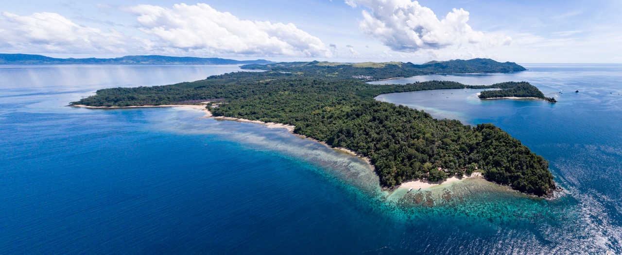
About 2.5 million people live in the province of North Sulawesi, located at the northeast end of Sulawesi. This region has a rich natural beauty, including beaches, hills, volcanic mountains and scenic plateaus. The Bunaken Marine National Park, a UNESCO World Heritage site, is the most famous tourist attraction in the area due to its biodiversity and rich coral ecosystem.


North Sulawesi is projected to be a major tourism destination for Indonesia in the future. As a result, the Indonesian government is currently accelerating tourism development, in part by constructing infrastructure and buildings suited for a mid-range to luxury market. This is especially true in Likupang, the easternmost tip of North Sulawesi.
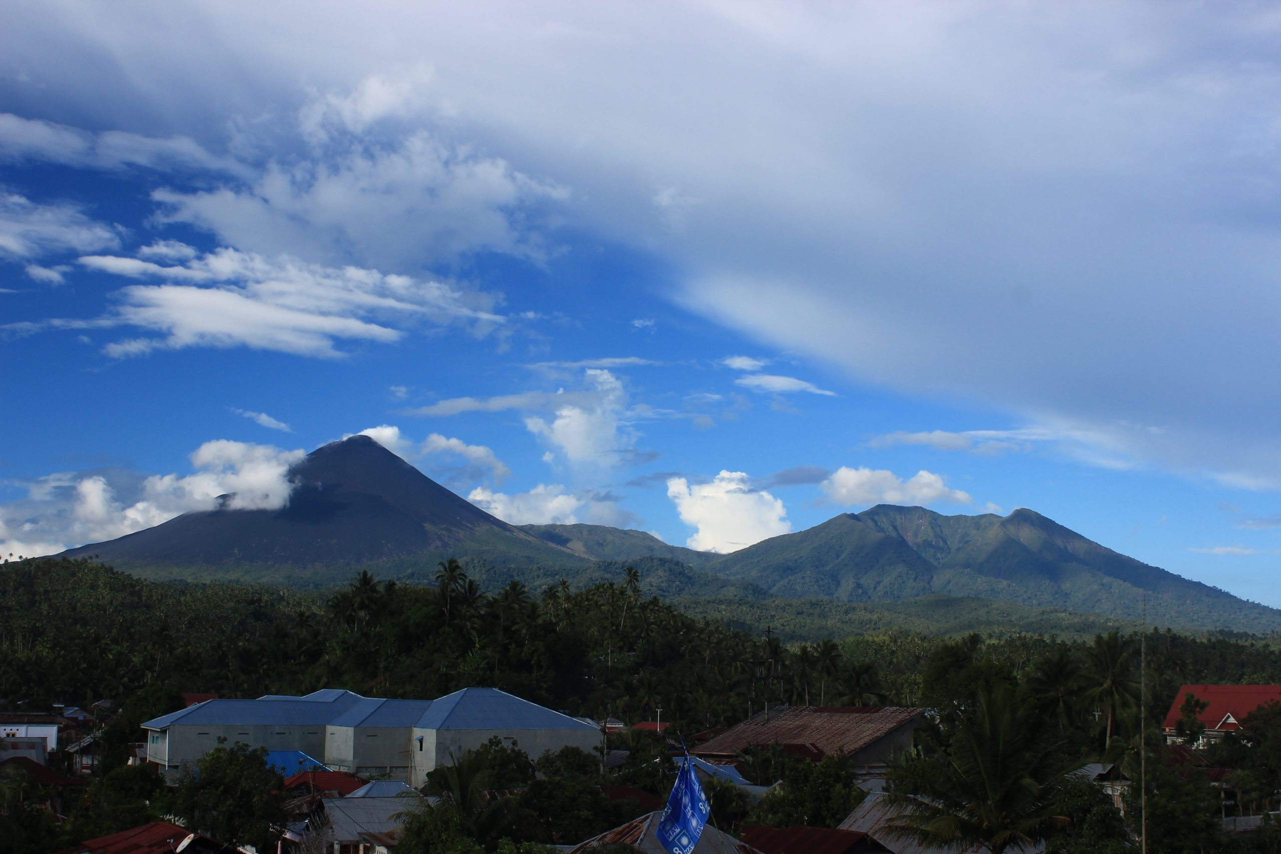
Sulawesi owes its beauty — and the natural hazards that threaten residents and visitors — to geologic drivers: a complex and active tectonic setting. The K-shaped island sits between the convergence of several tectonic plates: the Indo-Australian, Pacific, Philippines Sea and Eurasian plates. As a result, Sulawesi, and in particular North Sulawesi, faces various tectonic-related hazards, including earthquakes, tsunamis and volcanic activity.


Considering the tectonic setting, there is an urgency to accompany the boom in building with education and training about natural disasters. Until recently, there has not been a targeted training program for Indonesian residents about potential hazards, mitigation efforts and risk reduction actions. Here we describe the hazards the people of Likupang face, and what we as scientists are doing to help them better protect themselves and visiting tourists.
Historic natural disasters near Likupang
The offshore area of Likupang is close to the Maluku (or Molucca) Sea Collision Zone and Celebes Sea. The main tectonic forces come from the Indo-Australian Plate subducting under the Eurasian Plate, but there are many smaller microplates that complicate the region and add complexities to the hazards.
For instance, in the Maluku Sea, there is a divergent double subduction zone, which means that the oceanic Maluku microplate (a small tectonic plate) is being subducted both to the east and west, creating two arcs. The western side of the double subduction zone is the Sangihe arc, where the Maluku microplate subducts under the Eurasian Plate. On the eastern side is the Halmahera arc, where the Maluku microplate subducts under the Philippine Sea Plate.
The active volcanoes of the Sangihe arc extend along North Sulawesi, up to the Philippines. The active volcanoes of the Halmahera arc lie across the Maluku Strait. The tectonic activity in this region causes the high level of seismicity in this area, including shallow earthquakes, intermediate-depth earthquakes and deep earthquakes. Shallow underwater earthquakes can cause tsunamis.


Historically, there are several major natural phenomena that have affected the Maluku Sea region. From 1990 through April 2007, 397 earthquakes with magnitudes between 4.0 and 7.4 have been recorded. Of these, 13 earthquakes were destructive, with four generating tsunamis. These earthquakes generally nucleated beneath the Maluku Sea or other nearby bodies of water.
Recently, earthquakes occurred in the area surrounding Likupang, directly affecting this district. For example, a magnitude-7.1 earthquake on July 2019, located 36 kilometers below the Maluku Sea, caused a tsunami warning to be issued in North Sulawesi, though no tsunami damage occurred.
In addition to earthquakes, North Sulawesi also has the potential to experience impacts from volcanic eruptions. There are numerous active volcanoes offshore of Likupang, including Mt. Soputan, part of the Sangihe arc and the most active volcano in the area.

Disaster education
To better understand how North Sulawesi residents consider risks from natural hazards, my team and I interviewed local government officials, school personnel and community members from December 2021 to January 2022. Based on this effort, we learned that there was no disaster education activity for the population in Likupang.
Considering this, we designed an educational program for residents of the Likupang area. Our program is supported by Direktorat Pengabdian dan Pemberdayaan Masyarakat Universitas Indonesia (Directorate of Community Service and Empowerment), and focuses on reaching high school students between 15 and 18 years in age. Our idea was to educate high school students and raise awareness at an early age about disaster potential and mitigation. Furthermore, they could serve as communicators to their peers, families and communities.
To reach this goal, we conducted an in-person seminar and workshop about disaster potential and mitigation. Our seminar was attended by 100 students, teachers and community members. Our presentation included an overview of natural disaster potential in Likupang due to the geology, tectonics and volcanic setting. We discussed infrastructure resilience in Likupang, and talked about what to do before, during and after disaster strikes. Participants were enthusiastic during the seminar and workshop; they asked lots of questions and paid close attention.


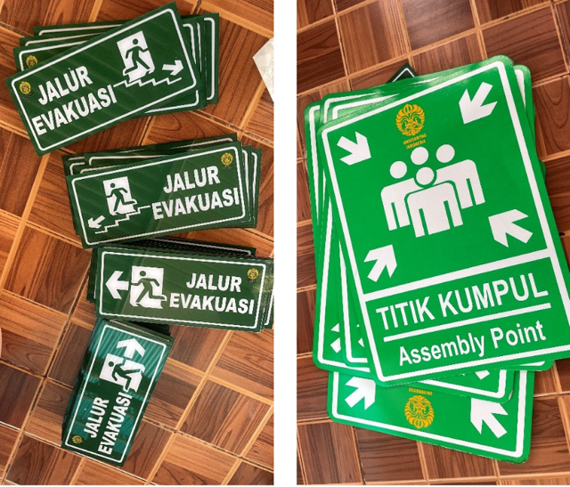
As part of our ongoing efforts at community education, we designed infographic banners that provide information about what to do when a natural hazard strikes. The infographics include information about how to save yourself during earthquakes, tsunamis, landslides or volcanic eruptions. We placed these banners in schools, at a local district office and within community areas. We also designed and posted signs for evacuation routes at designated places that might help the evacuation process in the future.


Future endeavors
Considering the enthusiasm of the students, teachers and community members, we believe our initial educational efforts have been successful. Through this endeavor we were able to introduce the hazards within the area to local communities and provide important knowledge regarding how to act before, during and after a hazard strikes. We asked the participants to share this knowledge with others, such as parents, peers and other community members. The infographic we posted in the government office can be used to educate other members of the community. The evacuation route and signs distributed within the community can help guide people when disaster strikes.
We plan to maintain our relationship with these communities and continue to educate them about potential hazards. We are also planning to visit surrounding regions in North Sulawesi that still lack disaster and mitigation education.


Acknowledgments
Special thanks to all team members involved in this project: Paulus Jirre H. Tahitu, Faneza N. Mardania, Benita A. Hutahean, Wangi Akbar M. Panuntun, Altheamira Chrisma F. Latuheru and Thessalonica S. Lowing.
References
Hall, R., and Wilson, M. E. J. (2000). Neogene sutures in eastern Indonesia, J Asian Earth Sci 18, 781–808,
Kushendratno, Pallister, J.S., Kristianto, Bina, F. R., McCausland, W., Carn, S., Haerani, N., Griswold, J., Keele, R. (2012). Recent explosive eruptions and volcano hazards at Soputan volcano—a basalt stratovolcano in north Sulawesi, Indonesia. Bull Volcanol 74, 1581–1609, https://doi.org/10.1007/s00445-012-0620-2
Silver, E. A., Moore, J. C. (1978) The Molucca Sea Collision Zone, Indonesia. J. Geophys. Res. Solid Earth 83 – B4, 1681 – 1691, https://doi.org/10.1029/JB083iB04p01681
Zhang, Q., Guo, F., Zhao, L., and Wu, Y. (2017). Geodynamics of divergent double subduction: 3-D numerical modelling of a Cenozoic example in the Molucca Sea region, Indonesia. J. Geophys. Res. Solid Earth. 122-5, 3977-3998, doi: 10.1002/2017jb013991
